Dungeness
©Dr Damian Laidler
©Dr Antony Long
Region: South East
Owner Type: Crown
Funding Body: Aggregates Levy Sustainability Fund; Colyer-Fergusson Charitable Trust
Year of Intervention: 2003 - 2004
Summary: Dungeness: Precise dating of the largest gravel cuspate foreland in Britain reveals the history of storms, sea-level, and coastal evolution in the eastern English channel over the past 5000 years, informing the management of the archaeology on the foreland and the shoreline.
Description: This landscape is a large gravel beach which forms part of the barrier complex that extends across Rye bay from the cliffs at Fairlight to Hythe.
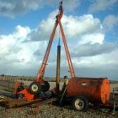
Issue: Rapid coastline change and significant on-going aggregate extraction present a considerable threat to the archaeology and palaeoenvironmental resources on the foreland.
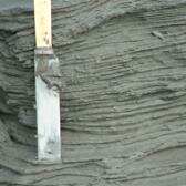
Strategy: Innovative use of high-resolution luminescence dating of sands and gravels, magnetic dating of fine-grained sediments, and radiocarbon dating of organic deposits, have been combined with relative dating of landform units in a mathematical model. This provides a detailed chronology for the formation of Dungeness.
Outcome: The result of this dating technique has improved understanding of the landscape history of Dungeness, and the significance of the surviving resource. This will be used to inform the management of the archaeology on the foreland and the shoreline.
Keywords: Assessment and Characterisation, Management Plans
© Peter. A, Long. A, Waller. M, Roberts. H, Laidler. D, Schofield. E, and Stuppers. P