Somerset Peatlands Project, Harters Hill Pile Alignment
©Richard Brunning
©Richard Brunning
Region: South West
Owner Type: Private
Funding Body: English Heritage; Environmental Agency; European Union; Somerset County Council
Year of Intervention: 1997 - 2003
Summary: Somerset Peatlands Project: Tree-ring dating helps determine the significance of a Monument at Risk through desiccation and peat wastage and thus inform the development of a management strategy for Harter's Hill Pile Alignment.
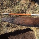
Description: A waterlogged late Bronze Age ritual pile alignment was revealed by peat shrinkage in Queens Sedgemoor near Glastonbury.
Issue: Waterlogged structures such as this and the well-known prehistoric track ways from the Brue valley are at risk from peat wasteage which will destroy 0.45 to 0.79m of peat in grassland and up to 2m in arable cultivation over the next 100 years. This is enough to destroy all the nationally important wetland monuments in the Somerset moors including 15 scheduled monuments.
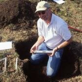
Strategy: The strategy for this case study was to provide absolute dating of the remains in order to determine its significance, and thus help in the design of a long-term management strategy. This was to ensure sustainable management of the waterlogged archaeology through determining its significance, extent, and depth, and designing an appropriate hydrological management regime
Outcome: The desired outcome is the sustainable management of a nationally important archaeological monument that was under threat (possibly to be funded under the Agri-Environment scheme).
Keywords: Disaster Management, Management Plans, Sustainability
Web Links:
© Richard Brunning