Worcestershire Tithe and Inclosure Map Project
Region: West Midlands
Owner Type: Many
Funding Body: Worcestershire County Council; Local Heritage Initiative
Year of Intervention: 2004
Summary: The Worcestershire Tithe and Inclosure Map Project: digitised 18th and 19th Century cadastral maps provide a highly accessible record for research, education and as a planning tool.
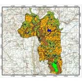
The aim was to digitise all the tithe and inclosure maps and associated apportionments for the county. A pilot study funded by Worcestershire County Council led to the development of a robust methodology
- Tracing of originals at County Record Office
- Taking digital images of apportionment books
- Digitisation of tracings using ArcView
- Entry of all information from apportionment books into an Access® database linked by field parcel number to the ArcView map theme.
The result was publicised. Many local groups were interested in commissioning the production of a digitised version of the tithes maps in their area using Local Heritage Initiative funding. The result was both a GIS theme on the Corporate GIS and the County Historic Environment record and an on-line version, hosted by Worcestershire County Council
The project is not yet finished but the work already completed indicates that it has been successful in
- Protecting the original documents
- Increasing use of the data held within the original documents
- Increasing awareness of the value and importance of the data both within the county council, districts, local societies and the general public
- Providing an invaluable resource for the Historic Environment Record useful for management, research and education purposes.
- Being recognised as an exemplar of good practice by the National Archive and other local authorities
Keywords: Assessment and Characterisation, Education and Outreach, Research & Archives