Craster radar station
©R Thomas
©RJ Thomas
Region: North East
Unitary Authority: Northumberland
Owner Type: Trust
Funding Body: National Trust; English Heritage
Year of Intervention: 2003
Summary: Investigation and field survey of Craster radar complex by English Heritage, working in partnership with the National Trust, involved the local community in the research process and allows improved management of a wider area, also serving as an exemplary piece of research into World War II military structures.
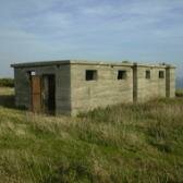
Description: Craster radar station, later converted to a PoW Camp, overlooks a beautiful stretch of coastline about ¼ mile north of the fishing village of Craster. The site, which is owned by the National Trust, lies in rough pasture, partly overgrown by gorse and the adjacent Whin Sill is an SSSI. The site is only accessible to visitors on foot and lies ¼ mile inland from popular coastal footpath.
Issue: The nearby stretch of the coastal footpath leads to Dunstanburgh Castle and therefore experiences particularly heavy use leading to erosion and compaction of pasture. The study of the Radar station was intended to create a second historic focus, allowing the National Trust to guide visitors along a circular walk, reducing erosion on the coastal route. This early type of radar (Chain Home Low) is nationally rare and poorly understood: secrecy and the spreading of deliberate disinformation make it difficult to retrieve reliable historical evidence. Much of the radar complex was overgrown with dense gorse, making research and presentation difficult.
Strategy: The National Trust requested and jointly funded an investigation and analytical field survey of the site by English Heritage. Targeted gorse clearance, carried out by National Trust volunteers, was built into the management plan for the SSSI, allowing study of the earthwork remains of the whole complex, rather than just the two surviving standing buildings. Recording and interpretation of the buildings was also carried out in exemplary detail, including gathering of oral history from local residents and people who served at the site.
Outcome: The site is now the best-understood and best-recorded example of its type in Britain and as such is of Schedulable quality; the SMR and NMR have been upgraded accordingly. Based on the new understanding, a management plan is currently being formulated to allow the National Trust to present the monument as an alternative focus of historic interest and so, hopefully, to divert numbers of people away from the over-used coastal path. Through their involvement in the research process, local people have developed a greater interest in and appreciation of their historic environment.
Keywords: MANAGEMENT PLANS, RESEARCH & ARCHIVES, SOCIAL INCLUSION & ACCESS
© English Heritage/S Ainsworth and RJ Thomas