Dunstanburgh Castle
©English Heritage/A Oswald
©English Heritage/A Oswald
Region: North East
Unitary Authority: Northumberland
Owner Type: Trust
Funding Body: National Trust; English Heritage
Year of Intervention: 2003
Summary: Investigation and analytical field survey of Dunstanburgh Castle and its landscape context by English Heritage revealed the extent and importance of the monument to be far greater than previously believed, necessitating changes to its management and presentation.
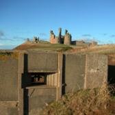
Description: Dunstanburgh Castle stands on remote sea cliffs, about 1 mile north of the fishing village of Craster, with farmland (predominantly pasture) inland and a golf course to the north. This extremely beautiful stretch of coastline is owned by the National Trust, and there are important wetland habitats surrounding the castle outcrop. The castle is owned by the National Trust and is managed under EH Guardianship. The site is only accessible to visitors on foot.
Issue: As a show castle, Dunstanburgh is more impressive from without, often leading to disappointment for visitors who pay the entrance fee. Although serious mismanagement by the National Trust was obviously never likely, ignorance of the significance of archaeological features in the surrounding landscape has led to minor damage, which could potentially have been repeated.
Strategy: The local Inspector of Ancient Monuments, together with the National Trust Regional Archaeologist, requested an investigation and analytical field survey by English Heritage of the castle and its landscape context to identify, interpret and record features of archaeological importance. The work was publicised to local people from an early stage and a guided tour at the end of the research attracted an impressive turn-out; a live daily web diary made the detailed findings accessible to a wider audience.
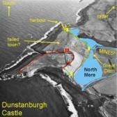
Outcome: The analytical earthwork survey demonstrated that the castle stands at the heart of an extensive designed landscape dating to around 1313, of schedulable quality, and the SMR and NMR have been upgraded accordingly. The identification of a probable Iron Age hillfort underlying the castle defences and widely scattered medieval, post-medieval and Second World War features are allowing a new management plan to be formulated for the whole environs of the castle, balancing the needs of the ecological and historic environments. The new discoveries offer opportunities for more imaginitive presentation of the castle, incorporating self-guided tours of the monument’s landscape setting, thus giving visitors a ‘better value for money’ experience. Through their involvement in the research process, local people have developed a greater interest in and appreciation of their historic environment. The live web diary offers an exemplary case study of the process of analytical field survey.
Keywords: Management Plans,Presentation and Interpretation, Research & Archives
© English Heritage/A Oswald, S Ainsworth and T Pearson