Force Crag Mine
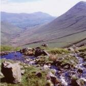
©A Oswald/English Heritage
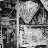
©A Oswald/English Heritage
Region: North West
Local Authority: Allerdale
Owner Type: Trust
Funding Body: National Trust; English Heritage
Year of Intervention: 1999
Summary: Investigation and analytical field survey by English Heritage of the abandoned mining complex improved understanding of its historic development in advance of a possible disaster, informing subsequent management decisions and also serving as an exemplary piece of research into mining complexes in general.
Description: Force Crag Mine, the last working metal mine in the Lake District, lies at the head of the remote and beautiful Colebrook Dale, the main ore processing building overlooked by a sheer cliff (Force Crag). The surface remains of the site, which is owned by the National Trust, are scattered over hundreds of hectares of upland rough pasture. The site is only accessible to visitors on foot and lies 1¼ miles from the nearest public road.
Issue: Prior to the survey, the National Trust had been advised by commercial mining engineers that the combination of a geological fault and decades of accumulated water in the disused workings might cause scree and mine spoil to slip suddenly and without warning into the valley bottom burying structures and potentially passers-by. Previous research had focused largely on the standing building and no accurate plan of the other remains was available. Though the recent history of the mine was well documented and understood, its earlier development was not, so quantification and interpretation of the surrounding historic environment was essential both to inform management decisions and as a record, in the event of the disaster.
Strategy: The National Trust requested and jointly funded an investigation and anlaytical field survey of the site by English Heritage, excluding the below-ground workings. To understand the function of features lying at the threatened core of the site, the survey was extended to associated remains in the surrounding landscape.
Outcome: The site is now one of the best understood and best-recorded mine complexes in the Lake District National Park, with potential for presentation to visitors. The broad-brush approach resulted in the discovery of unsuspected prehistoric and early post-medieval monuments. The SMR and NMR have been upgraded. Ironically, comparison of the English Heritage survey with historic maps and plans indicated that past slippage was less severe than the engineering report had initially suggested, and therefore that the threat was not imminent. Based in part on the new understanding of the archaeological remains, the National Trust has taken measures to further safeguard the site’s future. Well informed emergency conservation work has been undertaken, and management plans are being drawn up for the site’s long-term management and presentation.
Keywords: Disaster Management, Management Plans, Research & Archives
© A Oswald/ English Heritage