Rapid Coastal Zone Assessment Survey of Suffolk

©NMR/English Heritage
©NMR/English Heritage
Region: East of England
Local Authority: Suffolk Coastal
Funding Body: English Heritage
Summary: Rapid Coastal Zone Assessment Survey of Suffolk- informing coastal planning policy through recording of the inter-tidal archaeological resource.
Description: Changes taking place around the UK coastline have long been identified as having an impact on the archaeological resource. Coastal erosion, deposition and the movement of sediments around the coast have always influenced the survival of the archaeological resource within the inter-tidal zone and along the coastal littoral. Modern pressures (such as global warming, leading to an increase in mean sea level; the exploitation of coastal resources, through such activities as dredging; and new coastal defensive measures) have increased the pressures on the long-term survival of archaeological deposits, both along the coast and in the inter-tidal estuaries.
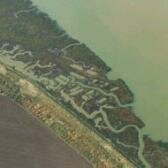
Issue: Suffolk's intertidal zone is predominantly composed of relatively unconsolidated materials, laid down during the Pleistocene or Holocene periods. Whilst extensive deposition, in the form of mud-flats, salt mashes, sand dunes and shingle spits, does occur, there are lengthy stretches where erosion, along both coast and estuaries, predominates. Unsurprisingly therefore pressures on the modern coastline are many and varied, and a growing need to manage the changes that continue to take place has become imperative.
Strategy: In order for archaeology to feed into strategic coastal planning policies it is, in the first instance, important to know what is there. Therefore English Heritage funded a coastal survey of the area, which was undertaken by the Suffolk County Council Archaeological Service. The basic aims of the survey have been to provide an overview of coastal changes from the Late Palaeolithic onwards. provide an assessment of the degree and nature of threat to coastal historic assets. Provide a broad assessment of the likely archaeological potential and vulnerability of all stretches of the coast. Provide a sound basis for developing management and research priorities in respect of specific sites and areas of potential including, and enhance public understanding and enjoyment of the coastal heritage.
To achieve these aims the project has taken two separate approaches; a desk-based programme involving: the plotting of archaeological features from major aerial photographic collections, in accordance with guidelines produced for English Heritage's National Mapping Programme, along with a study of all readily available map and documentary evidence, and a walkover field survey of the intertidal zone of the Suffolk coast and estuaries.
Outcome: The desk-based work programme commenced in September 1999, and is not likely to reach completion until August 2004, due to the enormous amount of archaeological data recovered from aerial photographic sources. To date the survey has recorded 1140 new sites, the vast majority of which related to Suffolk’s Second World War coastal defences. These include extensive linear defences consisting of minefields, barbed wire, concrete anti-tank cubes and scaffolding, interspersed with pillboxes and gun batteries. The survey has also recorded specialist military sites such as the research stations at Bawdsey and Orford Ness. New sites have also been recorded in the inter-tidal zone including oyster pits, fish traps and various wrecks and jetties, the majority of which are likely to be of medieval or post medieval date. This project therefore illustrates the wealth of archaeological material found in England’s coastal zone. It will inform strategic coastal planning policies, insuring that the historic environment is given necessary consideration in its management.
Keywords: Management Plans, Research & Archives
© English Heritage